
How Kootenai County grew: five times bigger since 1970, and almost all of it from people moving in
The county has gone from 35,000 people to nearly 192,000. Here's where the newcomers come from, what happened to home prices, and what the growth is doing to roads, water, sewer and schools.
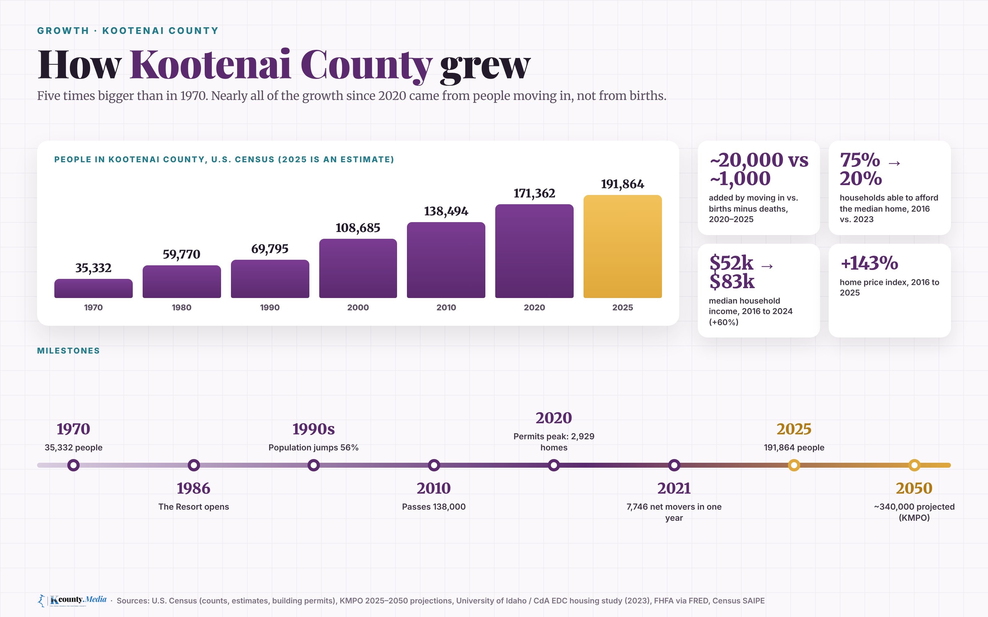
In 1970, about 35,300 people lived in Kootenai County. The Census Bureau now estimates nearly 192,000. The county is more than five times bigger than it was then, and the region's planners expect it to keep growing to about 340,000 people by 2050.
This is the overview of our series on how each town grew. Here is where the new neighbors come from, what homes cost now, and what all that growth is doing to the roads, the water, the sewer plants and the schools.
Five times bigger
The county grew in bursts. In the 1970s it jumped about 69%, from 35,332 people to 59,770, according to Census counts. The 1980s were slower. Then the 1990s brought another jump of about 56%, to 108,685. The Coeur d'Alene Resort opened in 1986 and drew national attention to the lake.
The county passed 138,000 in 2010 and reached 171,362 in the 2020 Census. The Census Bureau's latest estimate is 191,864 as of July 2025.
Almost all of the recent growth is people moving in. From April 2020 to July 2025, about 19,900 more people moved into the county than moved out, by the Census Bureau's estimates. Births outnumbered deaths by only about 1,000. The biggest single year was the one that ended in July 2021, when about 7,700 more people arrived from other parts of the country than left.
Where the newcomers come from
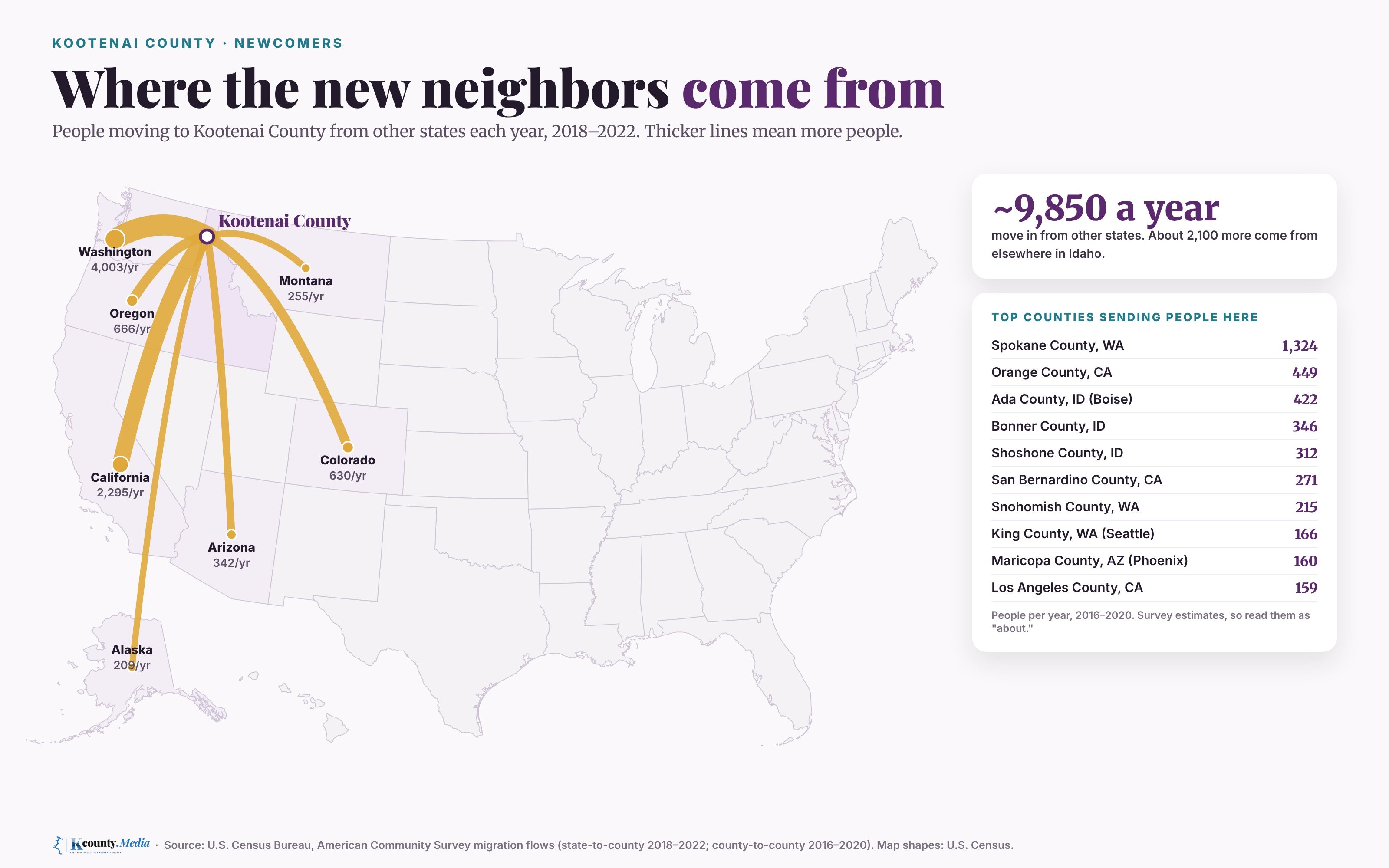
In an average year from 2018 to 2022, about 9,850 people moved to Kootenai County from another state, the American Community Survey estimates. About 2,100 more came from elsewhere in Idaho.
Washington sent the most, about 4,000 a year. California was second, at about 2,300. Oregon and Colorado each sent more than 600 a year, followed by Arizona, Montana and Alaska.
The single biggest source is next door. In the Census Bureau's county-to-county estimates for 2016 to 2020, about 1,300 people a year moved here from Spokane County. Orange County, Calif., and Ada County, home of Boise, each sent roughly 400 a year. These are survey estimates with wide margins of error, so read them as "about."
What homes cost
Prices rose much faster than pay. A study for the Coeur d'Alene Area Economic Development Corp. and the University of Idaho found that in 2016, the median home cost about $220,000 and about 75% of the county's households could afford it. By 2023, the median was about $525,000, mortgage rates were near 7%, and fewer than 20% of households could afford it. The study figured a family needed about $130,600 a year to buy that median home.
Federal housing data tell the same story. The Federal Housing Finance Agency's price index for the county rose about 136% from 2016 to 2024. Over the same years, the county's median household income rose about 60%, from about $52,000 in 2016 to about $83,300 in 2024, by Census estimates.
Part of the problem is supply. Builders pulled permits for 2,929 new homes in 2020, the most on record in the Census permit data going back to 2000. Since then the pace has slowed, to about 1,780 a year from 2023 to 2025. The 2023 study estimated the county needs at least about 2,700 new homes a year this decade to keep up.
Can it hold the growth?
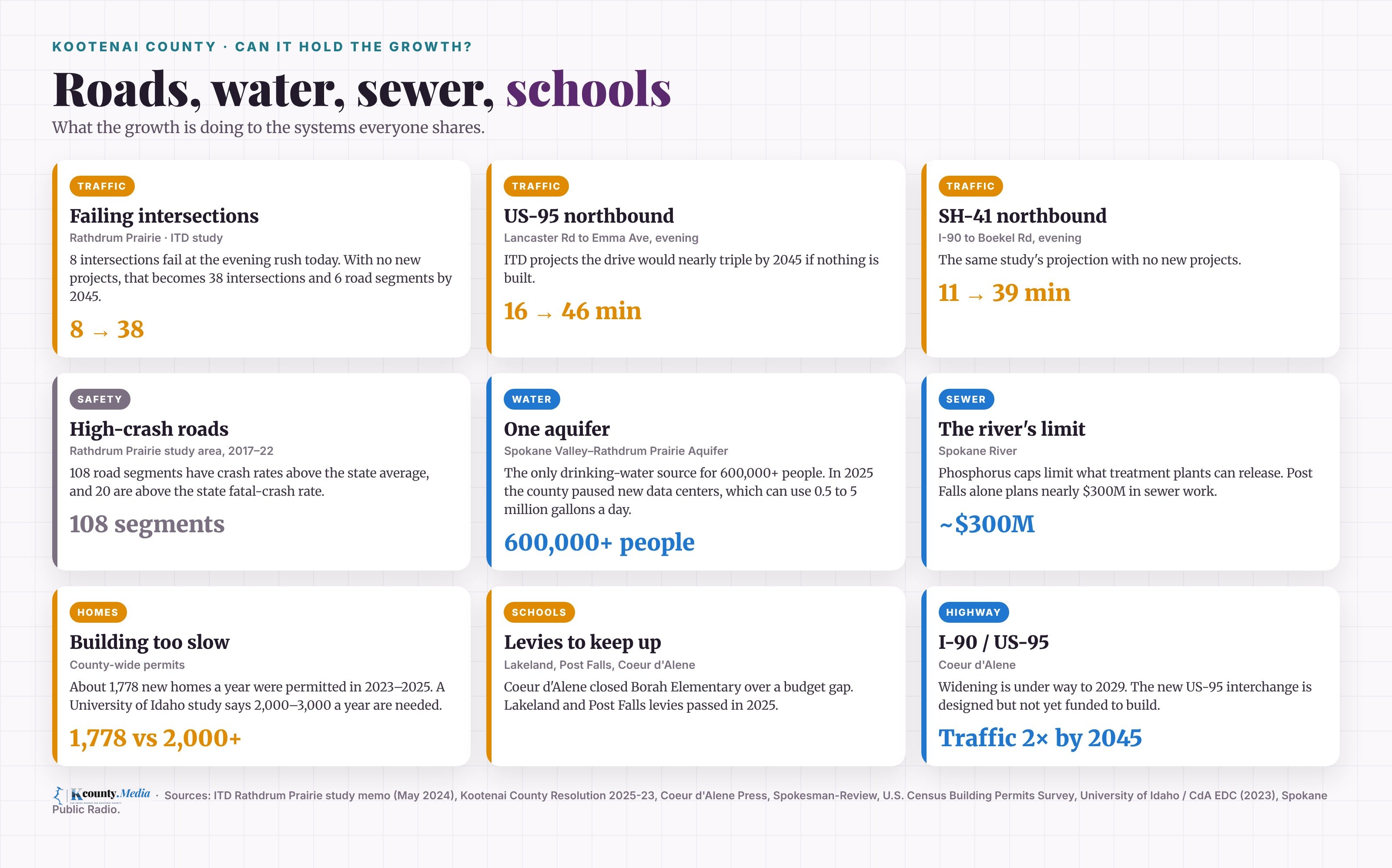
The traffic. The Idaho Transportation Department studied traffic on the Rathdrum Prairie, north of I-90. In 2023, eight intersections there were rated E or F at the evening rush, the two worst grades. If nothing new is built, ITD projected 38 intersections at those grades by 2045, plus six road segments. The evening drive north on US-95 from Lancaster Road to Emma Avenue would go from about 16 minutes to about 46. On Highway 41 from I-90 to Boekel Road, it would go from about 11 minutes to about 39. The same study found 108 road segments with crash rates above the state average.
Some relief is under way. I-90 is being widened to four lanes each way between Post Falls and Coeur d'Alene, a project that started in August 2025 and is due to finish in 2029.
The water. The Spokane Valley-Rathdrum Prairie Aquifer is the drinking water source for more than 500,000 people in Kootenai and Spokane counties, and federal regulators named it a sole source aquifer in 1978. In March 2025, county commissioners paused new data center permits in the unincorporated county for 182 days, saying a data center can use between 500,000 and 5 million gallons of water a day.
The sewer. Post Falls sends its treated wastewater into the Spokane River, which has strict limits on phosphorus. To stay under its cap as it grows, Post Falls approved a wastewater plan in 2024 with nearly $300 million in work and 2.5% yearly rate increases.
The schools. In 2024, facing a budget gap of about $6 million, the Coeur d'Alene School District voted to close Borah Elementary, Spokane Public Radio reported. In May 2025, voters approved two-year levies for the Post Falls and Lakeland districts. On Nov. 3 the Post Falls district asked voters for a new levy of about $6 million. Early returns on election night showed it passing, KXLY reported. The count is not final until the county certifies it.
How the towns compare
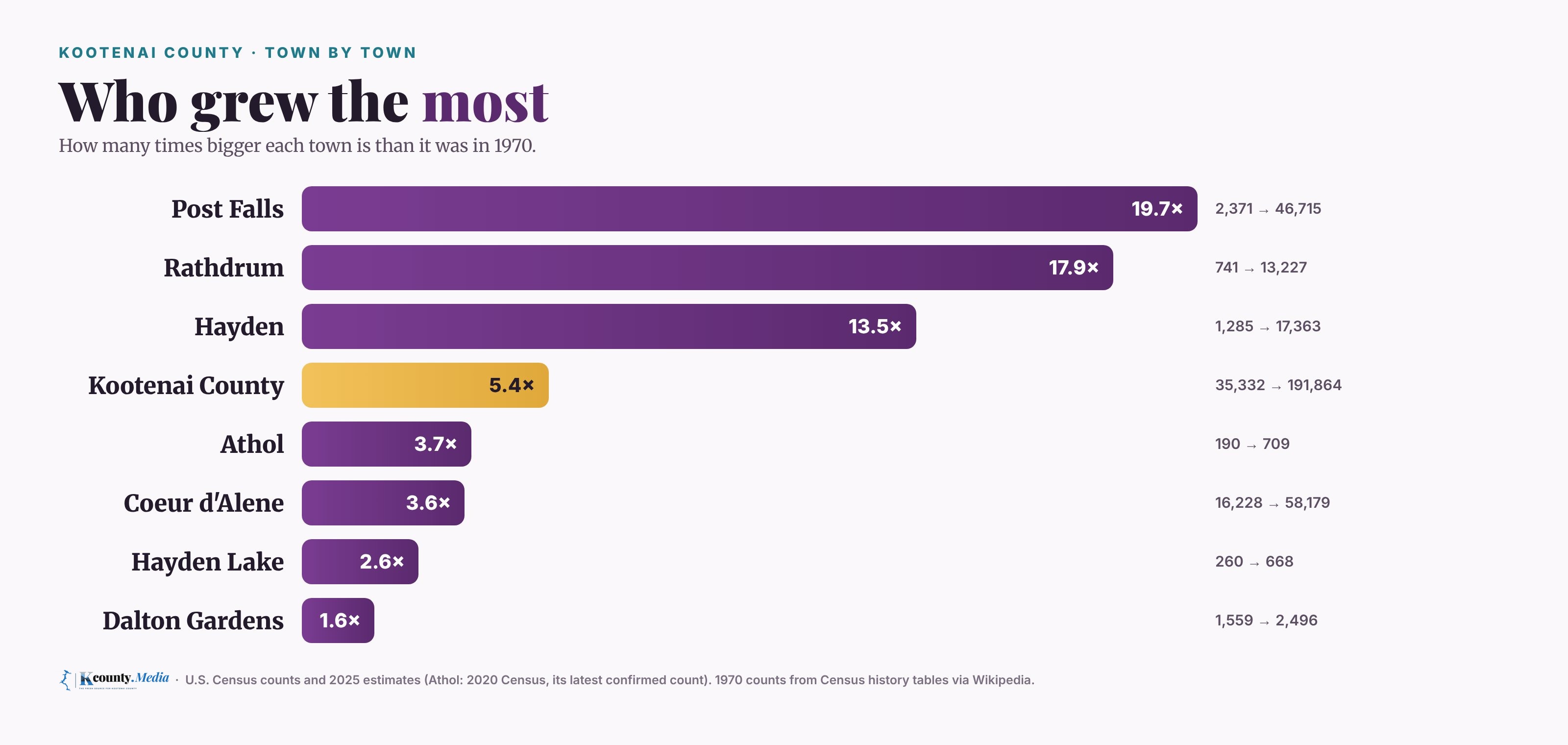
The growth has not been spread evenly. Post Falls has grown almost twentyfold since 1970, from 2,371 people to an estimated 46,715. Rathdrum grew about 44% from 2020 to 2025 alone, to about 13,200, the fastest of the county's cities over those five years. Hayden reached about 17,400.
Coeur d'Alene, which already had more than 16,000 people in 1970, is about 3.6 times bigger, at about 58,200. And Dalton Gardens, with its large lots, has barely moved: 1,559 people in 1970 and an estimated 2,496 in 2025.
Where it's headed
The Kootenai Metropolitan Planning Organization, the region's transportation planner, projects about 340,000 people in the county by 2050, up from about 195,000 by its 2025 count. It expects households to grow from about 76,000 to about 132,000. By its count, Post Falls passes Coeur d'Alene as the county's biggest city around 2045.
A county of 35,000 has become a county of nearly 192,000, and it isn't done. Live here, or thinking about it? Tell us what you're seeing. Every number in this story names its source below.
Sources
- Wikipedia: Kootenai County, Idaho (Census history table)
- U.S. Census Bureau: County population estimates and components of change, 2020–2025 (Vintage 2025)
- U.S. Census Bureau: City and town population estimates, 2020–2025 (Vintage 2025)
- Wikipedia: Coeur d'Alene, Idaho (Census history table, Resort opening)
- Wikipedia: Post Falls, Idaho (Census history table)
- Wikipedia: Dalton Gardens, Idaho (Census history table)
- U.S. Census Bureau: State-to-county migration flows, ACS 2018–2022
- U.S. Census Bureau: County-to-county migration flows, ACS 2016–2020
- CdA EDC / University of Idaho: Next Steps, the Updated Housing Availability and Affordability Study for Kootenai County (Oct. 2023)
- FHFA via FRED: All-Transactions House Price Index for Kootenai County, ID
- U.S. Census Bureau SAIPE: County median household income, 2024 (2016 from the same series)
- U.S. Census Bureau via FRED: New private housing units authorized by building permits, Kootenai County
- ITD: Huetter Corridor to Rathdrum study, Purpose and Need memo (May 2024)
- ITD: Construction begins to widen I-90 between Post Falls and Coeur d'Alene (Aug. 2025)
- Kootenai County: Resolution 2025-23, data center building permit moratorium (Mar. 2025)
- City of Post Falls: Wastewater Treatment Master Plan approved (June 2024)
- Spokane Public Radio: Coeur d'Alene school trustees approve budget cutting measures (Apr. 2024)
- Spokane Public Radio: Voters approve school levies in five North Idaho districts (May 2025)
- KXLY: Voters so far passing Post Falls school district levy (Nov. 3, 2026)
- KMPO: 2025–2050 Growth Projections (Feb. 2026)