

Outdoors app
The lake, the trails and the seasons: fishing, hunting, hiking and boating in Kootenai County.
Canfield Mountain trails
Canfield Mountain Single Track Trail System
Run by the Coeur d'Alene River Ranger District of the Idaho Panhandle National Forests. The system was designed for motorized trail bikes and mountain bikes, and hikers are welcome. Motorized trail bikes have used the mountain since the late 1950s.
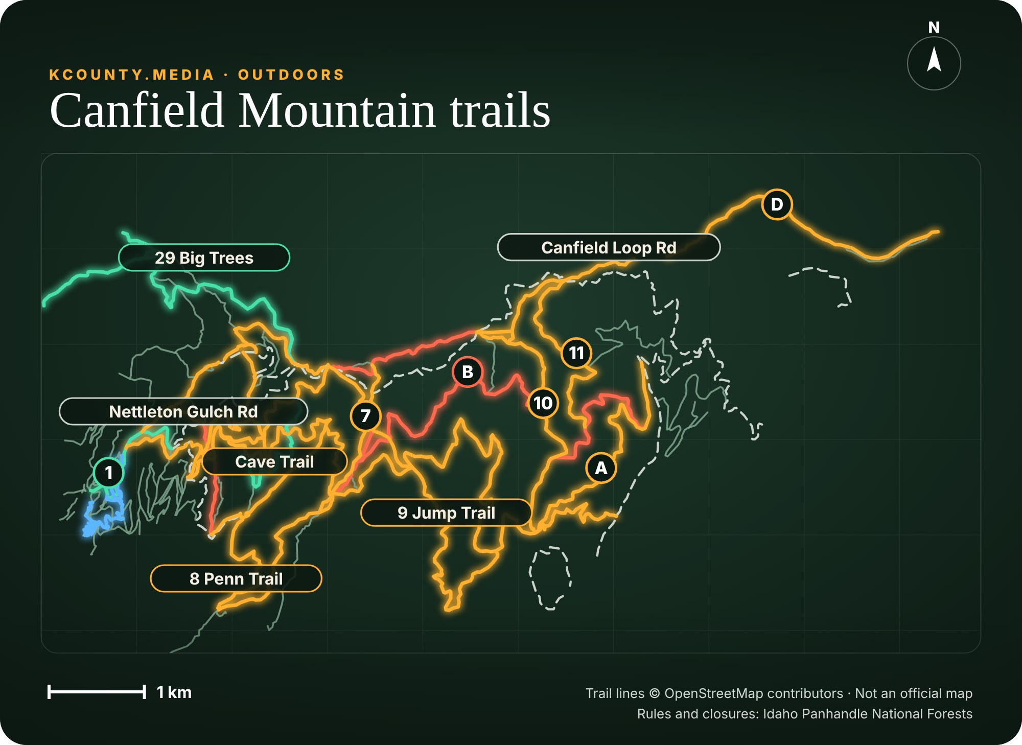
Map key
- Bikes and motorcycles both allowed
- Bikes allowed (motorcycle use not tagged)
- Motorcycles allowed (bike use not tagged)
- Bike-only trails
- Forest road or 4WD track
- Other mapped path
- Circled letter or number: trail name (A to D, 1 to 11)
The trail lines and use tags come from OpenStreetMap volunteers, so this is a guide and not the official map. The Forest Service trail map and the signs at the trailhead rule. Trail 1562 is the one trail open to four-wheel ATVs.
The rules
- Three- and four-wheel ATVs, dune buggies and jeeps are not allowed, except on Trail 1562, which is open to four-wheel ATVs.
- No fires, campfires or stove fires west of Fernan Road (Forest Road 268) from May 10 to October 20 each year. That order ran through October 20 this year and repeats annually unless it is rescinded. Breaking it is a misdemeanor with a fine of up to $5,000.
- Share the trail: bikes, motorized bikes and hikers all use the same system.
Getting there
- East side, Shooting Range parking: I-90 Exit 15 (Sherman Ave.), east on County Road 108 for 5.5 miles. It becomes Forest Road 268, and the parking area is on the left.
- West side, Nettleton Gulch parking: I-90 Exit 14 (15th Street), north 1.1 miles to Nettleton Gulch Road, turn right and go 2.2 miles.
Maps: the Forest Service posts the trail map online. A more detailed map with a description of each trail is free at the Fernan office, 2502 E. Sherman Ave., Coeur d'Alene, weekdays 7:30 a.m. to 4 p.m. Call (208) 664-2318.
Source: Forest Service trail page, updated March 26, 2026 · Fire restriction order. Trail conditions and access change with the season and weather.
Tubbs Hill trails
Tubbs Hill, downtown Coeur d'Alene
A wooded hill of 135 acres on the lake, publicly owned and part of the City of Coeur d'Alene's park system. The main trail is a two-mile loop around the hill, marked with "loop trail" signs. The city's brochure says to allow about two hours.
The trail
- Start at the south end of the Third Street parking lot, between McEuen and The Coeur d'Alene Resort. A large map stands at the trailhead.
- Numbered wood markers run the whole loop. The suspension bridge is at marker 18.
- At the one-mile halfway point a second route crosses the fire road and climbs to the top of the hill.
- Sanders Beach, a swimming beach, is along the shore on the east side of the hill.
The rules
- Dogs are allowed on a leash. Clean up after them.
How it became public
- 1882: Tony A. Tubbs files a claim that takes in much of the hill.
- 1936: the first 33 acres are bought for $19,000.
- 1969: 34 more acres are bought and the hill is dedicated to the public.
- 1974 and 1977: the last two pieces, 34 acres each, are bought.
Source: City of Coeur d'Alene, Tubbs Hill brochure (trail map inside), read November 11, 2026. The brochure is not dated; check the signs at the trailhead for current rules and closures.
Farragut State Park
Farragut State Park, Athol
Four thousand acres on the southern tip of Lake Pend Oreille, in Kootenai County. It was the Farragut Naval Training Station in World War II: ground was broken in March 1942, the base closed in June 1946, and 293,381 sailors took basic training there. It became a state park in 1965.
What is there
- More than 40 miles of trails for hiking, biking and horses. More than 20 miles are open to horses, all north of Highway 54.
- Five 18-hole disc golf courses: The Wreckreator, Northstar, A.W.O.L., Cutthroat and Little Black Bear, a short course for beginners.
- Eagle Boat Launch, which the park calls the only major boat access on the south end of the lake.
- Beaver Bay Beach, a sand beach. No pets, glass or hard-sided boats in the beach area.
- Camping, ten cabins, equestrian sites and group camps.
- In winter: cross-country ski trails, snowshoe trails and sledding.
- The Museum at the Brig, open Memorial Day through Labor Day, 10 a.m. to 4 p.m.
Know before you go
- A motor vehicle entrance fee is due on arrival, all year. An Idaho State Parks Passport, a $10 yearly sticker for Idaho vehicles, covers it. Camping costs extra.
- Day-use areas are open 7 a.m. to 10 p.m. The winter visitor center is open 9 a.m. to 4 p.m.
- No fireworks. Burn bans come and go.
- 13550 E. Highway 54, Athol. (208) 262-4444.
Source: Idaho Department of Parks and Recreation, Farragut State Park, page updated September 16, 2026, read November 11, 2026 · Disc golf map. The park's events show under Outdoor events below when it posts them.
Outdoor events
Lake and conditions
Send us an outdoors event
How this section stays current: Lake level and conditions come from the same feeds as the Weather page. Seasons, limits and closures come from Idaho Fish and Game and the parks, each with its date. Local stories are researched, drafted and published by a person.